DC snow forecast: Searching For December snow signals across the DMV
November is wrapping up on a cold note. This week brings our first real taste of some wintertime cold to the D.C. region.
Highs on Tuesday and Wednesday are expected to be only in the thirties and lower forties, which are temperatures more typical of January instead of late November.
With this type of cold in place, and December beginning at the end of the week, the question whether or not any snow could be in our future has come up.
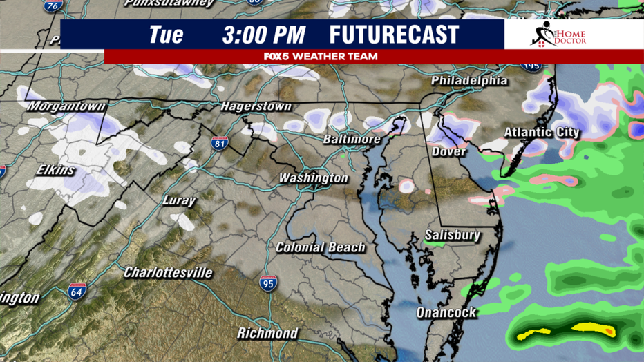
In the short term, the answer is surprisingly yes! Though we are not talking about the type of snow that could get you off a day of work. Instead, some gusty winds will blow into the D.C. region on Tuesday, but it is their direction that is actually important.
The winds will be coming directly from the Great Lakes region, all of which are unfrozen this early in the cold season. Enough moisture could sneak in with these winds that a passing is possible on Tuesday morning and afternoon.
Now, this of course, would not be anything other than "conversational" snow, but it would be the first chance I-95 has at seeing snowflakes as winter approaches. This, of course, would not be enough to satisfy snow lovers, but could any other snow be in our future?
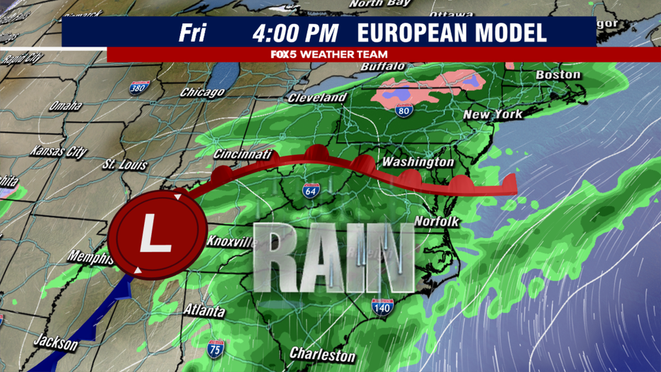
December begins on Friday, which is also the start of meteorological winter. For those who still are not sure why meteorologists do this, it is simply because of a way of gathering data in three-month cycles.
In ironic fashion, the start of the new meteorological season is likely to be greeted with rain. Not one, but two systems are possible in the Friday to Sunday time frame, and while the latter one this weekend could end up being similar to a coastal Nor’easter, it is expected to be a rain maker, not a snow maker.
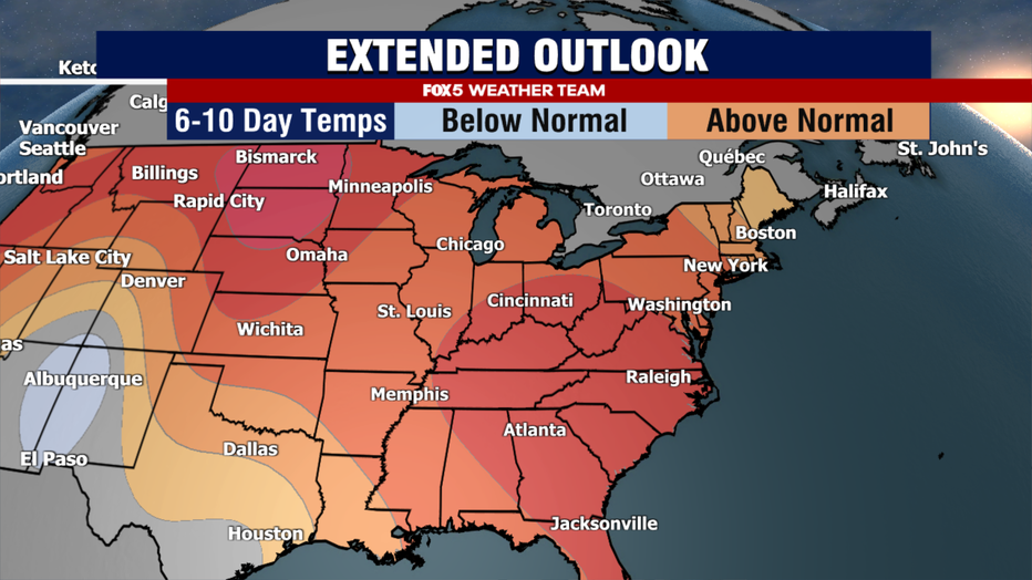
The reality is that after this cold snap at the end of November, the pattern looks like it will shift into one that is mild for December standards for much of the front half of the new month. Not warm enough for shorts and t-shirts to return, but likely too warm for snow.
However, before you think that this spells doom for the winter ahead, keep in mind that El Niño winters, more often than not, end up with warmer than normal temperatures. What tends to be more important as an indicator for the winter ahead, is whether or not we can keep an active storm track going for the East Coast.
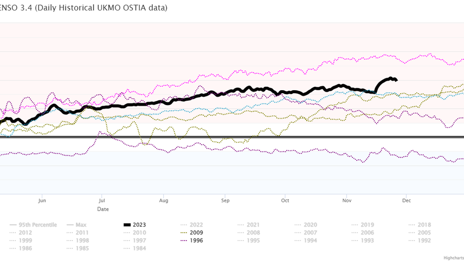
Speaking of El Niño, the key area we have been watching, known as Niño 3.4, took a big jump over the last two weeks, exceeding 2 °C above normal for the first time this year. Waters in the eastern Pacific continue to exceed 2 °C above normal as well, pushing this El Niño into the category as far as the daily data is concerned.
At the moment though, the waters remain cooler than they were during the 2015-2016 El Niño winter, when they were at record levels. Of the eight other years on record that were strong to very strong El Niño winters, only two (1957 and 1982) had more than an inch of snow in December, though both those years did produce between 6-12" of snow.
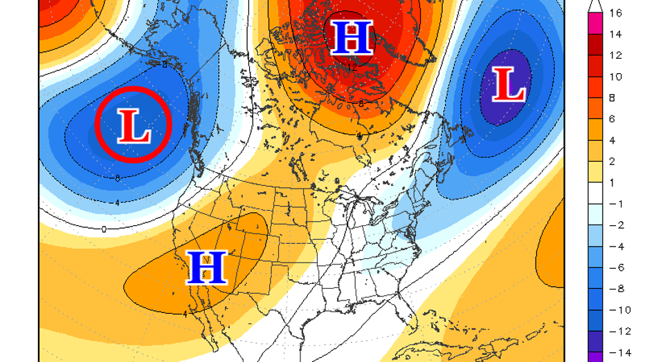
As we examine the long term forecast from several of the more reliable weather models, we see that the pattern the first week of December (above) we see a seasonally cool pattern.
A strong upper low in the North Atlantic (top right) the leftovers of a strong storm that is expected to bring rain to our region the tail end of the first weekend of December. A strong upper low in the Gulf of Alaska (circled, top left) will limit cold air transport eastward though. This is not a favorable pattern for snow.
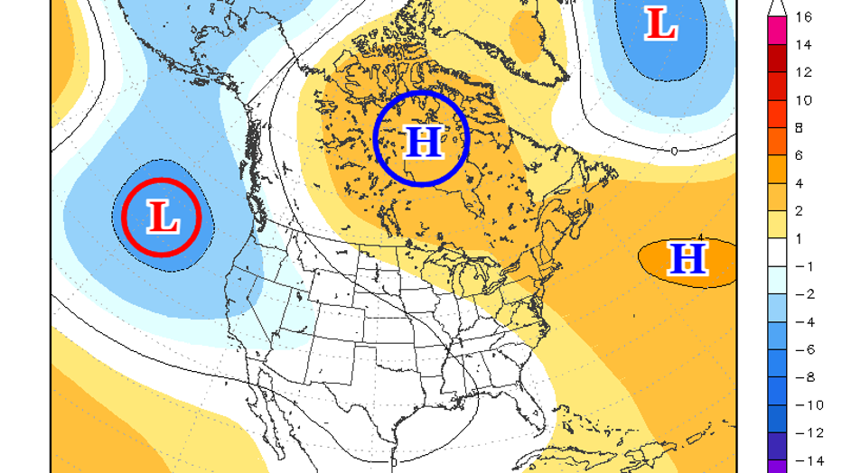
As we move into the middle of the month (shown above), this low (circled L, left) helps push the jetstream northward into Canada, favoring a ridge development across the Hudson Bay region (circled H, top) and likely will be echoed by in a stronger ridge building across the Northeast.
Not only is this not a favorable pattern for snow, but suggests that the middle of the month may be on the milder side.
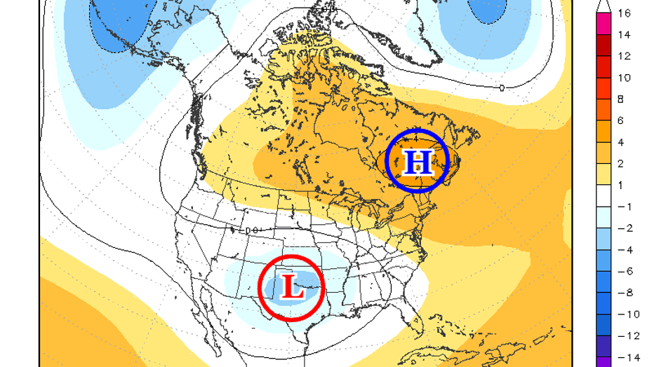
As we move into the week preceding the Christmas holiday (above) we see this same ridge (circled H) above that we talked about above centered across the eastern half of the country.
This is likely to promote milder weather at least at the start of the period. However, by this time the Alaskan low will also be weakening, allowing the jetstream to rebound southward.
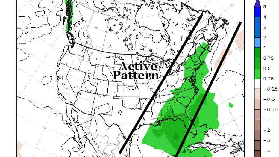
Pattern changes like this one are often accompanied by a sizable storm system, typically somewhere in the middle or eastern half of the county. The upper low over Texas (circled L) hints at that potential.
Certainly something that folks who have holiday travel plans will need to watch closely. Note that this time of pattern would not favor such a storm being a snow storm here in D.C. Though is a suggestion that behind this storm, colder air could return to the DC region just in time for the Christmas holiday.
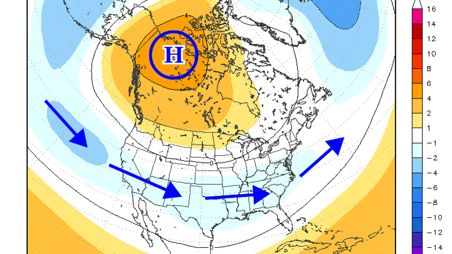
This brings us to the end of the month. The Alaskan low by this time had retrograded back towards the Bering Sea. This causes the same effect that happened in the Northeast at the beginning of the month with a building ridge, but this time focused across western Canada.
This suppresses the jetstream to the south, while also supporting cold air transport out western Canada into the eastern half of the United States. The southern extent of the jetstream may link up with the active, El Niño driven subtropical jet, which could mean an active period for storminess.
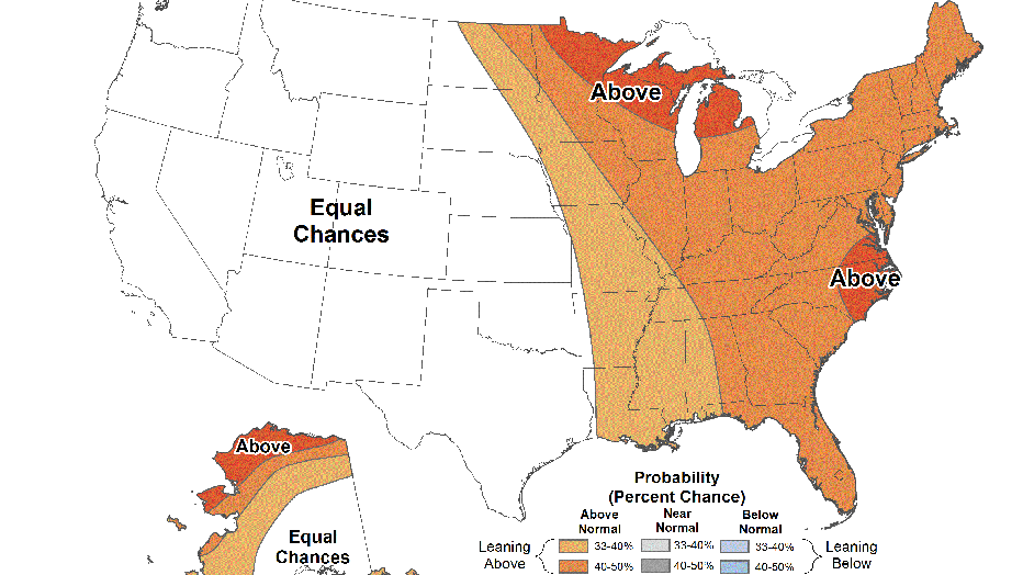
The conclusion is this. Despite a couple of outliers, strong El Niño winters are not typically known for their December snows. At the moment, we do not see any strong signs that the upcoming month is going to be any different. This was something that we did note in our winter weather outlookthat we released back in October.
Longer range guidance suggests that above normal temperatures will be favored through at least the week leading up to the Christmas holiday. If there is a chance for an impactful winter or snow events, it would be most likely after Christmas, with the pattern likely remaining cold into the start of the 2024 year.
We will continue to update you on any snow chances that happen to materialize! Stay tuned to Fox 5 and fox5dc.com!


